



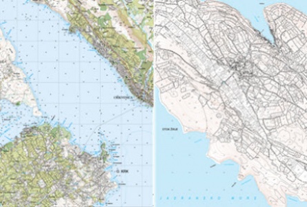
For the purposes of designing, Geoprojekt creates geodetic basemaps and digital topographic databases of different contents and precision levels, according to the requirements of designers. In addition to geodetic survey, infrastructure data and cadastral data are collected for the area of interest from competent institutions and offices.
Main data collection methods are geodetic field recordings using total stations and GPS receivers, as well as a photogrammetric method. Using topographic and topological data processing, generalization and cartographic editing, our experts produce basemaps for designing, topographic databases and topographic maps of different scales.
PRODUCTS:
Geodetic basemaps for design and on conceptual, main and performance levels, in scales from 1: 100 to 1: 5000
3D terrain models, special elevation maps, longitudinal and transverse profiles, volume calculation
Basic topographic database and Topographic maps in scale 1: 25000
Croatian basemap scale 1: 5000 (HOK 5)
Graphic addendums for the purpose of issuing special conditions and permits.
REFERENCES:
Basemaps for construction designing:
Geodetic works for the development of major projects and for obtaining building permits on the road Zlatar Bistrica - Andraševec (Bračak), 11.4 km long, Hrvatske ceste, 2014
Geodetic works for the expansion of the Slavonska avenija street from crossing with Čovićeva street to the crossing with LJ. Posavskog street: DTM, data on technical installations and basemap with cadastral borders in scale 1: 1000 together with Special geodetic basemap (PGP), IGH d.d., 2008
Geodetic works (DTM, topographic map 1: 100) for designing of the Main Project for the construction of new section of the State Road D2, Slatina bypass, Hrvatske ceste, 2006
Zagreb city bypass road: production of DOP5 and DOP1, DTM5 and DTM1, topographic map 1: 1000, Hrvatske autoceste d.d., 2006
Geodetic works for road reconstruction project: DTM and basemap 1: 1000, for sections:
state road D 49 Batrina - Pleternica (16,743 m)
state Road D 52 Špilnik - Babin Potok (23,315 m)
state road D 205 Risvica - Dubrovnik (10,407 m)
state Road D 206 Valentinovo - Petrovsko (8,303 m)
state road D 309 Samobor – Sveta Nedjelja (4,664 m).
Official cartography:
Basic topographic database and Topographic map 1:25000: 40 map sheets, 2000-2009
Updating of Basic topographic database and Topographic maps 1:25000: 20 map sheets, 2011-2016
Croatian basemap 1:5000: 75 mapsheets; from 2007-2009